


Preliminary flood risk assessment – I planning cycle (2011)
Preliminary flood risk assessment in the I planning cycle was developed within the project “IT System of the Country’s Protection against extreme hazards” (ISOK), financed from the European Regional Development Fund within the Operational Programme Innovative Economy. The project was carried out by the Institute of Meteorology and Water Management (IMGW-PIB) in consortium with the National Water Management Authority (KZGW), the Head Office of Geodesy and Cartography (GUGiK), the Government Centre for Security (RCB) and the National Institute of Telecommunications.
The preliminary flood risk assessment was made prepared by the Institute of Meteorology and Water Management PIB – the Centres of Flood Modelling in Gdynia, Cracow, Poznań and Wrocław in consultation with the National Water Management Authority.
Within the PFRA significant past floods have been identified, as well as floods that can occur in the future (so called probable floods), which provide basis to select identify areas at the risk of flooding.
|
For some of the areas at the risk of flooding, identified in the preliminary flood risk assessment, consequently flood hazard maps and flood risk maps have been prepared. In the I planning cycle it was not possible to prepare flood hazard maps for all the rivers indicated in the PFRA, due to the lack of detailed data, i.e. digital terrain model or rivers’ cross sections, necessary for hydraulic modelling. Flood hazard maps and flood risk maps for the rest of the rivers listed in the PFRA will be drawn in the next, second planning cycle. For the areas with the flood protection study prepared by the director of regional water management authority, such study, according to the article 14 of the act of 5 January 2011 on amendment of the Water Law act and some other acts, stays valid until the flood hazard map is made. According to the article 88c, par. 3-6 of the Water Law act (Journal of Laws of 2005, No. 239, item 2019 as amended) the President of the National Water Management Authority sent the project of the preliminary flood risk assessment to the appropriate province governors and marshals for an opinion. The project of the preliminary flood risk assessment, including resulting maps and the report, was sent to the governors and marshals of provinces on 28 September 2011 to obtain their opinion. The same day, the project of the preliminary flood risk assessment was published on the website of the National Water Management Authority. |
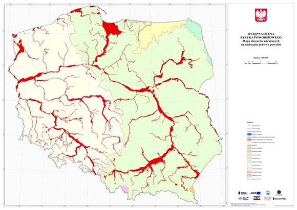 Flood risk areas identified in the preliminary flood risk assessment. |
Feedback on the preliminary flood risk assessment was sent back by 21 bodies. According to the article 88c, par.4, of the Water Law Act, the bodies that provided their opinions were notified on how their comments were processed. Among received opinions there were no remarks on preliminary coastal flood risk assessment, including sea inland waters, which would require arrangements with the minister appropriate for maritime economy, according the article 88c, par. 5, of the Water Law Act.